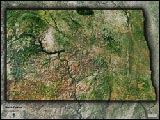
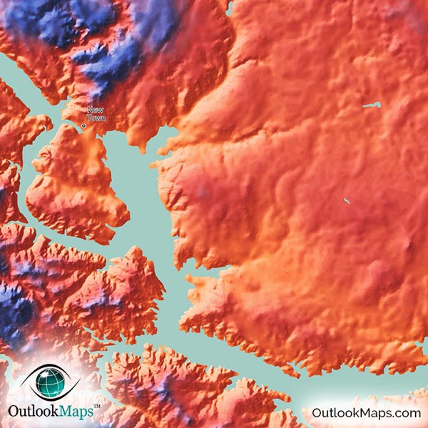
North Dakota Wall Map of Colorful Topography


(Click images to see full-size)
Note: The focus of this map is North Dakota's physical terrain. To maintain the artistic appearance, text labels are minimal.
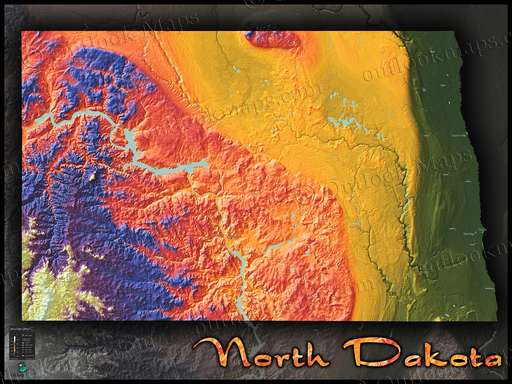
North Dakota's lowest elevation levels are shown in green. This primarily includes the vast Red River Valley in the eastern part of the state along the Minnesota border. Three of North Dakota's largest cities are located in this low-lying valley: Fargo, Grand Forks, and West Fargo. The Sheyenne River and James Rivers also create small valleys which reach this low elevation level.
As elevation increases westward across North Dakota, land colors change to golden yellow, orange, and red. This mid-level elevation includes much of the plains across central North Dakota, and nearly the entire Missouri River area and surrounding plateau. Bismarck, North Dakota's capital, is also located in this mid-elevation range.
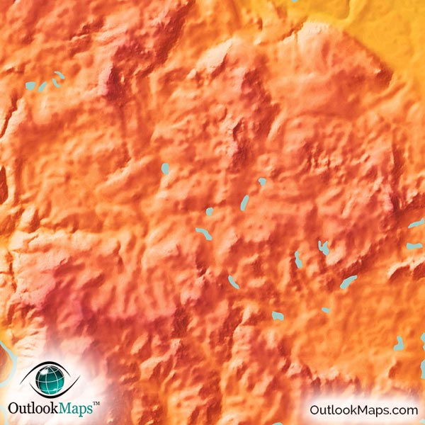
High elevation is colored blue and purple, with white used for only the highest points. North Dakota's high land is entirely in the western Badlands area, with the highest points in the southwest corner of the state. The specific high point of North Dakota is White Butte, at an elevation of 1069 meters, or 3508 ft.
Learn how this North Dakota topographic image was created with digital elevation data.
North Dakota, a state in the upper Great Plains, has several distinct topographical regions, all clearly visible in this physical map.
The upper portion of the badlands in southwest North Dakota are the most rugged and elevated part of the state, and includes the Theodore Roosevelt National Park.
The Missouri Plateau (or "Coteau du Missouri") is the high hilly area that surrounds the Missouri River in central North Dakota.
The Drift Prairie is east of the Missouri Plateau and comprised of very flat lands.
The Red River Valley is a wide and flat low valley in the east, that contains fertile soil and is home to much of the state's agriculture.
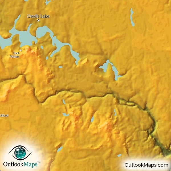
North Dakota's lakes, reservoirs, and wide rivers are also shown in the map. The Missouri River and lakes within it, such as Lake Sakakawea and Lake Oahe, are shown. Other lakes like Long Lake, Horsehead Lake, Lake Tschida, Lake Darling, Devils Lake, and Jamestown Reservoir, among others, are also shown in this physical map.
52 North Dakota cities and towns are labeled.
Major cities like Fargo, Bismarck, Grand Forks, Minot, Mandan, and Dickinson are all shown.
Some of the medium and smaller towns on the map include Wahpeton, Beulah, Grafton, Lisbon, Watford City, Stanley, Cavalier, Hettinger, Crosby, Lincoln, New Town, Harvey, Larimore, Shell Valley, Burlington, as well as many others.

At Outlook Maps, we put a tremendous amount of care into ensuring that our maps look great on display, and this North Dakota topographical physical map is no exception.
Vibrant colors and a stylish artistic presentation help make this map much more than a geographic reference map, but a work of art. Sure to look spectacular wherever you display it (home, place of work, classroom, or somewhere else), and have viewers captivated by the interesting North Dakota terrain they probably never even new existed.