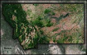
Montana Physical Features Topography Wall Map


(Click images to see full-size)
Note: The focus of this map is Montana's physical terrain. To maintain the artistic appearance, text labels are minimal.

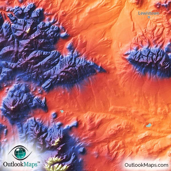
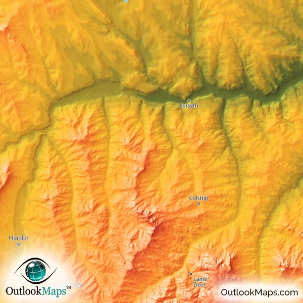
Green represents the lowest elevation in Montana. With the exception of a few valleys in the northwest mountains of Montana, the low areas are almost entirely in the eastern parts of Montana in the prairies of the Great Plains. The river valleys of the Missouri River, Milk River, Musselshell River, and Yellowstone River (all in the east) are very prominently visible low lands.
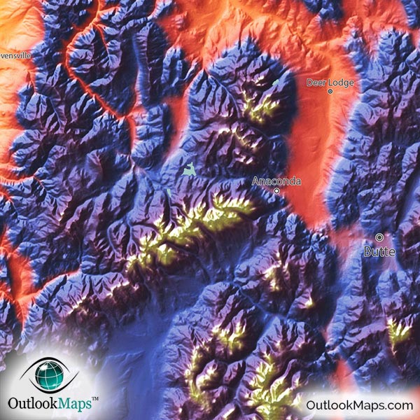
As elevation increases across the state, colors change to oranges and reds, representing relative mid-elevation levels. Most of this mid-elevation land is in the high plains and mountain foothills in the west and south, though some of the more rugged mountains in northwest Montana are still at only mid-elevation levels. Cities located in this mid-elevation range include Billings, Great Falls, Helena (Montana's capital), Missoula, and Bozeman.
High lands are colored with blue and purple, with the color white being reserved for only Montana's highest mountain peaks. Montana's high land is entirely in the western half of the state, especially in the southwest corner. Butte is the largest city located in the high-elevation range.
Montana's highest point is Granite Peak at an elevation of 12,807 ft (3904 m). Granite Peak is located near the Wyoming border in south-central Montana.
Learn how this Montana topographic image was created with digital elevation data.
This topographic physical style map really accentuates Montana's landforms, especially the many mountain ranges that streak across the western portion of the state. Many ranges within the Rocky Mountains are visible, including the Bitterroot Range along the Idaho border; the Cabinet Mountains, Mission Range, and Lewis Range in Northwest Montana; and the Pioneer Mountains, Beaverhead Mountains, Big Belt Mountains, Little Belt Mountains, Crazy Mountains, and the Absaroka Range across the southwest portions of Montana. Several smaller isolated mountain ranges also exist in central and eastern Montana, including the Bear Paw Mountains, Little Rocky Mountains, Bull Mountains, and Bighorn Mountains.
Specific peaks within the ranges are also visible. Granite Peak, Crazy Peak, Koch Peak, Saddle Mountain, and Red Mountain are all visible.
Montana's lakes and reservoirs are also shown in the map, including Fort Peck Lake, Canyon Ferry Lake, Flathead Lake, and many more.
A total of 86 Montana cities and towns are labeled.
All major cities like Helena, Billings, Missoula, Great Falls, Bozeman, Butte, and Anaconda are shown.
Some of the medium and smaller towns on the map include Lewistown, Polson, Hardin, Deer Lodge, Helena Valley Southeast, Belgrade, Conrad, Columbus, Forsyth, Choteau, Thompson Falls, Scobey, Orchard Homes, Lolo, Helena Valley Northeast, North Browning, Colstrip, East Helena, Three Forks, South Browning, Helena West Side, Manhattan, Absarokee, Plains, Eureka, as well as many others.

As any Montanan will attest, Montana's natural beauty is like no place on earth…and this physical map totally backs up that claim. The Rocky Mountains in the west are rugged and brilliant and even the plains in the east look amazing as the rivers can be seen cutting there way across the land heading east.
The coloration and style of this Montana physical map make it a beautiful work of art as much as a useful reference map. Whether you display the map in your home, office, or even a classroom, this map is sure to look spectacular on display and bring a colorful decor to any room.